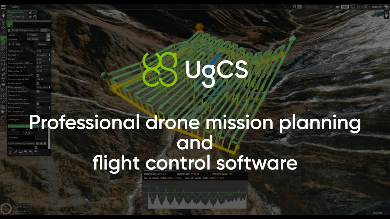
- For UgCS desktop software a computer running Windows/macOS is needed. All flight planning is done on the computer.
- To connect DJI drones to UgCS an Android mobile device or DJI Smart Controller is needed to run UgCS for DJI - the free mobile app.
UgCS License Types & Pricing
- Perpetual license
- Subscription
Navigating Licenses
Understanding Your Software Options
Choose the UgCS license that best suits your types of flights and tasks
Route creation from KML / CSV files
Exporting routes in KML
Export routes to KML for preview in Google Earth Pro
Terrain following
Plan flights with default terrain following or import your own elevation data
Customisable map
Import your own custom DEM/DSM and map overlays
Corridor inspections
Create a long corridor for power line, road, and pipes inspections
Vertical flight planning
Automate building inspections, import 3d models for facade scan
Go offline
Cache maps and elevation for offline use and plan your flights even in the most remote regions of the world
Assists in flying in areas with steep hills, maintaining an exact distance to the nearest surface
LiDAR tool
Automatic IMU calibration patterns (L1, L2, 8-figure, u-shape), adjustable corner radius and loop turns
Live video streaming
Stream live geotagged video from your drones from anywhere in the world
Up to 10 simultaneous drone connections
Connect multiple drones and use them together
Share your missions with the team
Set up a centralised UgCS server (locally or in the cloud) and share your routes and drone flight data across the team
UgCS SDK
Build custom solutions for your needs
Navigating Licenses
Understanding Your Software Options
Choose the UgCS license that best suits your types of flights and tasks
Route creation from KML / CSV files
Exporting routes in KML
Export routes to KML for preview in Google Earth Pro
Terrain following
Plan flights with default terrain following or import your own elevation data
Customisable map
Import your own custom DEM/DSM and map overlays.
Corridor inspections
Create a long corridor for power line, road, and pipes inspections
Vertical flight planning
Automate building inspections, import 3d models for facade scan
Go offline
Cache maps and elevation for offline use and plan your flights even in the most remote regions of the world
Assists in flying in areas with steep hills, maintaining an exact distance to the nearest surface
LiDAR flight planning tool
Automatic IMU calibration patterns (L1, L2, 8-figure, u-shape), adjustable corner radius and loop turns
Live video streaming
Stream live geotagged video from your drones from anywhere in the world
Up to 10 simultaneous drone connections
Connect multiple drones and use them together
Share your missions with the team
Set up a centralised UgCS server (locally or in the cloud) and share your routes and drone flight data across the team
UgCS SDK
Build custom solutions for your needs


Related products
Considering UgCS for your project?
Fill out the form and let's talk about:
1. Tasks you are trying to solve
2. How can UgCS help
3. How can UgCS be integrated within your team
Supported Drones
Wondering if your drone is supported in UgCS?
Minimum System Requirements
Operating system
- Windows 7 with SP1 or later; Windows 8; Windows 10/64-bit
- Mac OS X Maverick 10.9 or later / 64-bit
- Linux: Ubuntu 18.04 LTS / 64-bit
CPU
- Core 2 Duo or Athlon X2 at 2.4 GHz
Memory
- Recommended RAM: 4GB or more
Graphics hardware
- Graphics card with DirectX 9 support (shader model 2.0). Any card made since 2004 should work
Hard drive
- 2 GB of free space
Minimum supported screen resolution
- 1024 x 768
Common Questions
Got Questions?
We have you covered!
If you have any technical questions, feature suggestions or require to report an issue, please fill in the form - we will be happy to assist you.
What device do I need to use UgCS?
Is UgCS web-based or do I need to install it?
UgCS is not web based as we know how difficult it is to get an internet connection in remote regions where most of our customers are flying drones. That's why UgCS is installed locally on your computer and can run without an internet connection.
Where do I download UgCS?
The latest UgCS version are published on ugcs.com:
Is an internet connection required to use UgCS?
UgCS gives the ability to cache maps and elevation for offline use. So an internet connection is only required for first activation of the license and caching maps of a selected regions. After that you can use UgCS in the most remote regions on Earth without the need to connect to the internet connecting - with the drone using only local network (which can be setup using a router or contemporary mobile device as hotspot).
How do I connect my drone to UgCS?
- To connecting DJI drones to UgCS you need to have UgCS for DJI mobile app installed on either an Android mobile device or the DJI Smart Controller. The device then needs to be connected to the same local (internet is not required) network as the computer with installed UgCS installed and the drone will automatically appear in UgCS.
- To connect other supported drones such as Ardu / PX4 - a connection is established over radio telemetry link (with ground radio being connected to the computer over USB) or WiFi (not requiring internet connection).
How can I know if my drone is supported?
- The list of UgCS supported drones and autopilots is published on ugcs.com »»»
- If you have any questions or doubts you can always reach out to UgCS support team at support@ugcs.com
Do I need an Android device to fly a DJI drone with UgCS?
To connect a DJI drone to UgCS you will need either an Android mobile device connected to the DJI remote controller (RC) via USB or the DJI Smart Controller.
How can I install UgCS for DJI on DJI Smart Controller?
- First step is to download the .apk file of UgCS for DJI mobile app using Direct Download option from ugcs.com/dji.
- Next, save the .apk file on the Smart Controller, open it with the file browser app and install.
Is a laptop required in the field to fly with UgCS?
A laptop/computer with installed UgCS is required for flight planning, which can be done either in-field or in the office.
With DJI drones and the free UgCS for DJI mobile app, flights can be saved on the mobile device for offline (i.e. offline from UgCS desktop) use, making it not necessary to take out the laptop in the field.
!!! However, it is still recommended to have the laptop with you in the field in case any modifications or adjustments of the route need to be done.
Is iOS supported for UgCS for DJI?
The development of UgCS for DJI iOS app is currently suspended, meaning - it has only bee tested with UgCS version 4.3 but not later versions. The iOS app most likely could work also with newer versions but some bugs can arise - use at your own risk.We recommend to use the newest UgCS for DJI Android app.
Does UgCS support LiDAR IMU calibration?
Yes! The licensesUgCS EXPERT andUgCS ENTERPRISE provide access to figure-eight and U-shape / J-hook calibration patterns.
Which LiDAR sensors are supported by UgCS?
Most LiDAR sensors can be used as long as they are carried by a UgCS supported drone. UgCS officially supported LiDAR sensors / manufacturers:
- DJI L1
- YellowScan
- Phoenix LiDAR
- RIEGL
- LIDAR USA
- GeoCue
- Rock Robotics
- GeoSun LIDAR
- 3DT Scanfly.
Can I import a route from KML/CSV?
Yes! UgCS supports route creation from KML or CSV files.
In which format can I import DEM/DSM data?
The DEM/DSM terrain elevation data can be imported into UgCS as GeoTIFF (.TIF) format.
Is UgCS available in my language?
- UgCS is currently available in English, Spanish, French, German, Italian, Chinese, Russian and Latvian languages. The language can be set in Main Menu -> Configuration -> Language.
- UgCS for DJI mobile app is available only in English.
Do you provide UgCS training as well?
Are there any video tutorials on how to use UgCS?
- Yes! Diverse UgCS video tutorials and webinars are published on SPH Engineering's YouTube channel »»»
- If you'd like to see an in-depth explanation of a feature for which we do not have a video, please fill in the form or send an email to support@ugcs.com.
Can I fly vertical scan missions with UgCS?
Yes! UgCS gives you access to the Vertical Scan tool, allowing to perform vertical drone inspections of buildings, communication towers and other objects. The Vertical Scan tool is included in all UgCS license types.
Can I fly a route created in UgCS in DJI Pilot?
Yes! Routes from UgCS can be exported as KML format files and then imported and used in DJI Pilot/Pilot2.Video tutorial how to export from UgCS a route in KML for DJI Pilot/Pilot2 »»»
What is the difference between UgCS PRO, UgCS EXPERT and UgCS ENTERPRISE licenses?
In simple terms:
- UgCS PRO has all of the base functionality, including Vertical Scan tool
- UgCS EXPERT unlocks access to LiDAR flight planning tools and calibration patterns
- UgCS ENTERPRISE enables distributed installation of UgCS and to stream video from your drones to the PC via via WiFi/LTE.
Does UgCS offer a solution to process acquired data?
The UgCS Mapper software gives you access to a powerful processing tool allowing to perform in-field offline stitching of maps and creation of complex elevation profiles. The processed data can be imported "back" into UgCS and used to plan next flights.
UgCS Mapper also supports stitching of multispectral imagery and even live mapping from video using UgCS ENTERPRISE.
Currently, UgCS Mapper does not support stitching of vertical scan imagery or LiDAR data processing.
Help! I've got a technical problem with UgCS, who do I contact?
Send a message to support@ugcs.com and we will do our best to help you!Please provide detailed information of the issue to speed up the support process:
Working hours of UgCS Support: Mo-Fri 09:00-18:00 (UTC+02:00).
- which UgCS/UgCS for DJI version is installed,
- description of the issue,
- log files (attached .zip log folder to e-mail),
- screenshots,
- exported mission file,
- license code.